474 miles (764 km) / 33 days on foot

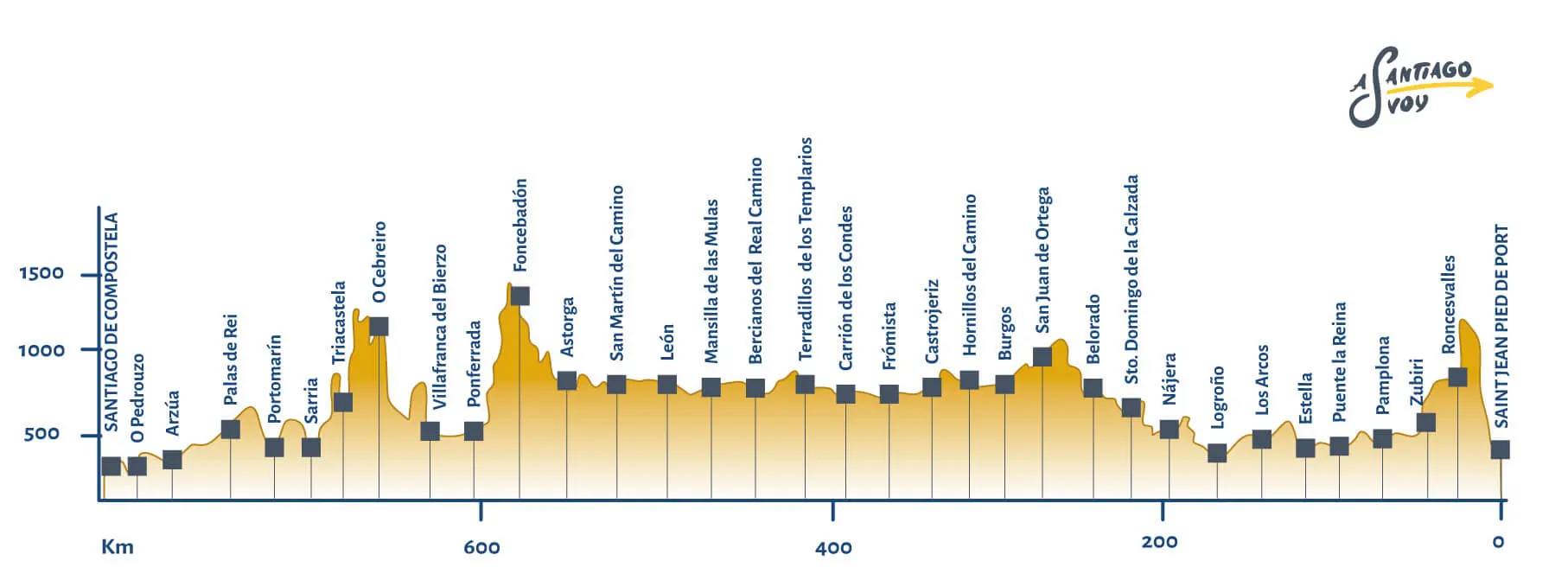
The French Way (or Camino Francés)

The longest and oldest route of the Way of Saint James.

Learn what the most popular route of the Camino de Santiago is like. Discover it stage by stage, including the obstacles you can find and the cultural aspects you can enjoy.

If you don't want to walk the entire Camino, remember you don't have to cover it completely. You can choose any intermediate starting point and complete the number of stages or miles you want. If you walk 100 km on foot, you will get the Compostela at your arrival at the Cathedral of Santiago.
And, if you want some help to organize your trip, do not hesitate to contact us.


Image: Fortaleza de Sarria

History of the Camino Frances

474 miles (764 km) / 33 days on foot / 14 days by bike


The French Way or Camino Francesis one of the paths with the most history. In fact, it is considered the oldest path, since there are archives about it from 1135. This is therefore the oldest documentation about the Way of Saint James. The Camino de Santiago emerged in the 9th century, with the discovery of the remains of the Apostle Saint James. Thanks to this event and to the support of King Alfonso II (who reigned at that time), the French Way begins to be travelled, both by the devotees of the Iberian Peninsula and by devotees in other regions of Europe.

The Way of Saint James not only had the support of King Alfonso II, but also the blessing of Charlemagne, emperor of a great part of Europe. There is no doubt that this fact contributed to increase the popularity of the myth of Saint James and the Way started to be travelled by people from all over Europe.

camino francés

Reasons to choose the French Way

The French Way is not only the oldest way, but it is also the most popular among pilgrims. The antiquity of the Camino Francés is a good reason to start walking on it. You can follow the same historic path as many people from all over Europe, visiting key places and fascinating points of interest.

Being such a popular route, you can benefit from many aspects. The stages of the French Way are always full of pilgrims (even in low seasons, such as fall or winter). The atmosphere is incomprable. In addition, the fact that it is the most frequented road has favored the opening of numerous establishments. In this way you won't have problems accessing hostels, restaurants, etc. This is particularly useful if you need to stop to rest before reaching the end of your stage.

if you do not feel able to start from Roncesvalles or it is the first time you make the pilgrimage, we recommend that you opt for the French Way from Sarria.

Logroño

Image: V. Maza

Burgos

Image: El fosilmaníaco

Leon

Image: J. A. Gil

Astorga

Image: P. Lameiro

Stages of the Camino Frances (French Way- 764km away)

The French Way begins in the famous town of Saint Jean Pied de Port, located in France, very close to the border with Spain. It consists of 33 stages and measures a total of 474.72 miles. The stages are between 11 and 19 miles each and you can discover places like Pamplona, Logroño, Burgos, León, Astorga, Ponferrada, Arzúa and many more.

Stage 1
Saint Jean Pied de Port – Roncesvalles (15 miles / 24.2 km)

This is a tough start to the stage. If you have problems, you can always deviate to Valcarlos, where the route becomes easier and more bearable. In this first stage you can enjoy beautiful landscapes, such as the Puerta del Pirineo, the entrance to Spain from France that so many pilgrims traveled before. In addition, the cuisine stands out, with the cheeses from the incredible mountain sheeps (Ossau Iraty, Roncal or Idiazabal), among others.

Description of stage 1, map and hostels

From roncesvalles

Stage 2
Roncesvalles - Zubiri (13.2 miles / 21.4 km)

To leave Roncesvalles, you must follow this agile route. You can do it by following the path, (which runs parallel to the main road) or divert slightly to run parallel to the main river, the Agra river. Both options are less demanding than the previous stage and are characterized by their beautiful landscapes, by having many services and by a unique gastronomy.

Description of stage 2, map and hostels

Stage 3
Zubiri - Pamplona(12.6 miles / 20.4 km)

This stage is popularly known as the stage of the bridges, given the high number of bridges that have to be crossed (the Bandidos Bridge, the Irotz Bridge or the Ultzama Bridge, among others). You will cross several meanders of the Agra river, as well as its tributaries. Finally you will arrive in Pamplona, the famous capital of the Sanfermines, where you can not miss its Cathedral, the Town Hall, the Palace of Navarre or the Walls, among other points of interest.

Description of stage 3, map and hostels

Stage 4
Pamplona - Puente de la Reina (14.8 miles / 23.9 km)

This stage runs through a particularly windy area. That will be your biggest challenge at this stage, since the orography is generous with the pilgrims. At this point, you have to say goodbye to the Agra River, and you'll cross the bridges over the Sadar River. You can visit the churches of San Miguel, San Andrés or San Esteban, as well as the Muruzábal Palace.

Description of stage 4, map and hostels

Stage 5
Puente de la Reina - Estella (13.4 miles / 21.6 km)

This 13-mile stage is rich in agricultural landscapes. Trigals, olive fields or meadows dyed with poppies are some of the wonders that await you at this stage. As for heritage, you can see the Palace of the Kings of Navarre, the Holy Sepulcher or the Wall in the town of Esteña. Its cuisine is not far behind: try the piquillo peppers and the rocas del Puy.

Description of stage 5, map and hostels

Stage 6
Estella - Los Arcos (13.2 miles / 21.3 km)

This stage is characterized by having desert areas and little shelter in some of its parts. It has a slight rise, but otherwise is a pleasant stage for the pilgrim. Do not hesitate to stop by to visit the Wine Fountain and the Monastery (in Irache), the Castle of San Esteban de Deyo, the Church of Santa María de Los Arcos or the Portal de Castilla. Wines and leche frita are some gastronomic specialties that you can enjoy in this area.

Description of stage 6, map and hostels

Stage 7
Los Arcos - Logroño (17.1 miles / 27.6 km)

In this stage, you will eave behind the Foral Community of Navarre to start touring in La Rioja. Here you will come across the most important Spanish river - the Ebro. You will also have the opportunity to taste the best wines of the Peninsula. This stage has some slopes with loose stones and gravel that can make your pilgrimage difficult. Visit the Church of the Santo Sepulcro in Torres del Río, the Viana City Hall and the points of interest of La Rioja's capital: the Church of San Bartolomé, the Co-Cathedral of La Redonda, the Church of Santiago and the streets of Laurel and San Juan, in Logroño.

Description of stage 7, map and hostels

From Logroño

Stage 8
Logroño - Nájera (18 miles / 29 km)

The length of this stage should not scare you, as it is bearable and does not harbor obstacles. On the contrary, there are only moderate slopes, almost everything is plain with vineyards and other agricultural fields. Churches, monasteries and convents (in Navarrete, Ventosa and Nájera) are some of its points of interest.

Description of stage 8, map and hostels

Stage 9
Nájera - Santo Domingo de La Calzada (12.8 miles / 20.7 km)

Another stage that is characterized by being flat and surrounded by fields dedicated to agriculture. You will pass through the Church of Nuestra Señora de los Ángeles (Azofra), the Monasteries of Suso and Yuso (San Millán de la Cogolla), the Cathedral and the Paseo del Espolón (Santo Domingo de la Calzada).

Description of stage 9, map and hostels

Stage 10
Santo Domingo de La Calzada - Belorado (13.6 miles / 22 km)

In this stage the border between La Rioja and Castilla y León is crossed. It is another plain area where you will pass by the remains of the Belorado Castle, the famous castle of El Cid. You can also start tasting the Castilian-Leonese cuisine, such as the lamb or black bloog sausage from Belorado.

Description of stage 10, map and hostels

Stage 11
Belorado - San Juan de Ortega (14.8 miles / 23.9 km)

This is one of the loneliest stages you will go through. In fact, many of the intermediate towns do not have public services such as an ATM, a pharmacy or accommodation, so you must be prepared. It is interesing to visit monuments like the Hermitage of Nuestra Señora de la Peña (in Tosantos), the Church of Santiago Apóstol (in Villafranca Montes de Oca) or the Monastery of San Juan de Ortega.

Description of stage 11, map and hostels

Stage 12
San Juan de Ortega - Burgos (16 miles / 25.8 km)

This path continues on flat surfaces. Although it is somewhat long, it is not particularly difficult. This path is close to the Atapuerca site, although it is not exactly on the road. Although you have to deviate a bit, it is a point of great interest. The Church of San Miguel de Arcés, the Cathedral of Burgos, the Cartuja de Miraflores and the Castillo de Burgos can't be missed.

Description of stage 12, map and hostels

From Burgos

Stage 13
Burgos - Hornillos del Camino (13 miles / 21 km)

When leaving Burgos, you will walk the same streets as in the original route. You will pass through the Jewish quarter of Burgos and leave behind its historic cathedral. The route continues to be flat and smooth. In fact, you may combine this stage with the next one, forming a long stage of 24.85 miles (40 km), but with no difficulties. Don't forget to try the Burgos cheese and the blood sausage.

Description of stage 13, map and hostels

Stage 14
Hornillos del Camino - Castrojeriz (12.4 miles / 20 km)

This stage, like the previous one, is about 12.4 miles long and it's flat and easy to cross. The wide Castilian agricultural fields will accompany you. You can visit the Church of the Virgen del Manzano in Castrojeriz and the Plaza Mayor and the City Council of Castrojeriz.

Description of stage 14, map and hostels

Stage 15
Castrojeriz - Frómista (15.3 miles / 24.7 km)

Here there is little shade so temperatures can be extreme (thi is natural in the interior of Castilla y León). In this stage there is only a small rise, followed by long plains.

Description of stage 15, map and hostels

Stage 16
Frómista - Carrión de los Condes (11.6 miles / 18.8 km)

This stage, being short, is relaxed and pleasant, since it does not have steep slopes either. You can take the chance to enjoy the Castilian-Leonese cuisine at its best: garlic soup, lamb, pichón and much more.

Description of stage 16, map and hostels

Stage 17
Carrión de los Condes - Terradillos de los Templarios (16.3 miles / 26.3 km)

According to the legend, the mythical goose that laid the golden eggs is burried in Terradillo de los Templarios. This stage is not difficult, as it is flat and pleasant. But you must bear in mind that, when leaving Carrión de los Condes, you will pass through locations with very few services (for example, pharmacies, hostels or restaurants). If you are prepared for this lonely stage, you will appreciate its monuments and landscapes.

Description of stage 17, map and hostels

Stage 18
Terradillos de los Templarios - Bercianos del Real Camino (14.4 miles / 23.2 km)

It's time to leave the are of Temple to continue crossing the fields of cereals of the wide Castille. You can visit the Church of Santo Tomás de Aquino (in Moratinos), the Church of San Lorenzo (in Sahagún) or the Hermitage of Nuestra Señora de Perales (in Bercianos del Real Camino). In the town of Sahagún is where you will again find plenty of services.

Description of stage 18, map and hostels

Stage 19
Bercianos del Real Camino - Mansilla de las Mulas (16.3 miles / 26.3 km)

Up to the 4th mile of this stage (approximately), services are limited. You must wait until you reach El Burgo Ranero, where they are most abundant. This stage is characterized by being flat and without obstacles.

Description of stage 19, map and hostels

Stage 20
Mansilla de las Mulas - León (11.4 miles / 18.5 km)

This stage links these small towns with the great city of León. Here you can reach the Cathedral, the Roman Wall, the Castle and many other majestic monuments. It is a plain and simple stage.

Description of stage 20, map and hostels

Stage 21
León - San Martín del Camino (15.2 miles / 24.6 km)

In this stage the old capital of Leon is abandoned to submerge us again in the grain fields of Castille and León, as well as on pavement. An opportunity to appreciate the landscapes and nature. Do not overdo it, as it is a stage not too long and flat and peaceful. It is usual to find industrial areas in the surroundings of big cities. Extreme caution is recommended because of the high level of vehicles in these areas.

Description of stage 21, map and hostels

Stage 22
San Martín del Camino - Astorga (14.7 miles / 23.7 km)

After passing the paved roads of the outskirts of León, you arrive at a more natural landscape, crowned by the historic Astorga, a place that you can not miss. Enjoy its Roman vestiges, its unique architecture and its delicious hojaldres and mantecados. What better to recover after the 14 miles of this stage?

Description of stage 22, map and hostels

From Astorga

Stage 23
Astorga - Foncebadón (16 miles / 25,8 km)

This stage has a very slight slope. Although it is not complex, you may feel it after the long flat stages throughout Castilla. The slope ascends until reaching the region of El Bierzo. Do not miss the cocido maragato and the fruits and vegetables of this area. The cherries from El Bierzo, for example, will help ease the sore muscles. There are only 10 stages left to get to Santiago de Compostela!

Description of stage 23, map and hostels

Stage 24
Foncebadón - Ponferrada (16.6 miles / 26,8 km)

In this stage, cyclists must be careful in some descents. The highest point of the Camino is at this stage, between the 3rd and the 6th mile (kilometers 5 and 10). Then there is an intense descent that ends in Ponferrada. As for points of interest, do not miss the Templarios Castle, the Clock Tower or the Basilica de la Encina in Ponferrada.

Description of stage 24, map and hostels

From Ponferrada

Stage 25
Ponferrada - Villafranca (15 miles / 24.2 km)

At this stage there is only a very slight slope from the 9th mile on (kilometer 15). You will begin to notice an increasing amount of vegetation. This means you're leaving Castille behind to enter the green and beautiful Galicia. On this day, you will pass by charming towns, such as Columbrianos, Componaraya, Cacabelos, Valtuille de Arriba, until arriving in Villafranca del Bierzo.

Description of stage 25, map and hostels

From Villafranca

Stage 26
Villafranca - O Cebreiro (17.2 miles / 27.8 km)

In this stage you have to reach O Cebreiro, a charming mountain town. The rise goes from around 1,300 to 2,600 feet above sea level, the highest rise being between 12th and 16th mile (km 20 and 27). It is therefore a considerable slope, which also occurs in a considerably long stage. If you have enough stamina, we recommend you to visit the Church of Santa María la Real and the famous pallozas in O Cebreiro.

Description of stage 26, map and hostels

Stage 27
O Cebreiro - Triacastela (12.9 miles / 20.8 km)

In contrast to the previous stage, this is a shorter and flatter stage, although it has a deep descent at the end, so cyclists must remain vigilant. This route runs through the magical Ancares region. The Camino does not pass through the Natural Park, but you can enjoy some of its delicacies: chestnuts, homemade sweets, mushrooms, cheese, etc.

Description of stage 27, map and hostels

Stage 28
Triacastela - Sarria (11.4 miles / 18.4 km)

This stage is characterized by having a firm and flat ground, mostly on paved ground. It is almost completely flat, so it is easy to travel on foot or by bike. In addition, it is one of the shortest stages, so you can take the chance to rest and admire its monuments: the Church of San Cristovo do Real, the Benedictine Monastery (in Samos) and the Church of San Salvador in Sarria.

Description of stage 28, map and hostels

From Sarria

Stage 29
Sarria - Portomarín (13.7 miles / 22.2 km)

The road to Portomarín has several ups and downs that make the journey a little bit difficult. In Sarria, you will be only less than 69 miles away from Santiago. Usually, you will find many pilgrims from this stage on, since this stage covers the minimun distance to obtain the Compostela. It is time to share the experience with your fellow pilgrims and to focus on enjoying the last stages to the fullest.

Description of stage 29, map and hostels

Stage 30
Portomarín - Palas de Rei (15.4 miles /24,8 km)

The way up from Poromarín to Hospital da Cruz has a slope of about 1,300 feet in just 7.4 miles. After this, the stage is quite flat and has quite a lot of paved areas. You can't leave without trying some good Galician bread, polbo á feira (octopus with paprika) or lacón con grelos (a dish with pork, potatoes and a special kind of collard greens).

Description of stage 30, map and hostels

Stage 31
Palas de Rei - Arzúa (17.7 miles / 28.5 km)

The last long stage of the Camino takes you from Palas de Rei to Arzúa. This path is characterized by being flat and quite close to sea level. You will have the opportunity to visit places such as Leboreiro, Melide or Boente. Its monuments include the Church of Santa María de Leboreiro, the Medieval Bridge of the Río Furelos, the San Roque Chapel in Melide, the Church of Santa María de Melide, the Ribadiso Bridge and the Church of Santiago in Arzúa. You will find yourself in one of the areas with the best Galician gastronomy: the octopus and melindres of Melide and the Arzúa cheese are some of the jewels in the crown.

Description of stage 31, map and hostels

Stage 32
Arzúa - Pedrouzo (11.9 miles / 19.3 km)

We are reaching the end and the last two stages are easier. With only 11 miles, this is a simple stage. You can see the Church and the Hermitage of O Pedrouzo and rest before your last day.

Description of stage 32, map and hostels

Stage 33
Pedrouzo - Santiago de Compostela (12 miles / 19.4 km)

This is a simple and short stage. In addition, the urge to reach Santiago tends to influence the pilgrims - their enthusiasm brings some extra strenght to get to Compostela. Once you have arrived in Santiago, don't just visit the Cathedral. The Galician capital offers you an endless number of places with history, charm and beauty that you can not miss: San Martín Pinario Monastery, Santo Domingo de Bonaval, the Mercado de Abastos, the Hostal de los Reyes Católicos. Or you can simply stroll through its fantastic streets and enjoy your arrival at your destination.

Description of stage 33, map and hostels

The French Way Profile

Best Accommodation on the French Way

If there is a Camino de Santiago in which the services and accommodations available for pilgrims abound, that is the French Way.

You will have so many options to spend the night, and located at such a short distance between them that we have chosen some of the best, so that when you have to rest in any of these stages you do not have to think about it much.

  • Estella

  • ANFAS Foundation Hostel (C. Cordeleros, 7)
  • Villafranca del Bierzo

  • Leo Hostel (C. Ribadeo, 10)
  • O Pedrouzo

  • Edreira Hostel (Rúa da Fonte, 19)
  • Santo Domingo de la Calzada

  • Cofradía del Santo Hostel(C. Mayor, 38-42)
  • Carrión de los Condes

  • Santa María Pilgrim's Hostel (C. Clérigo Pastor, 2)
  • Santiago de Compostela

  • Seminario Menor (Av. Quiroga Palacios, 2)

Discover all the different ways

The French Way (Camino Frances) is the most popular one, but there are many other ways you should know.

» French Way 474 miles / 33 days
» Portuguese Way 388 miles / 25 days
» Northern Way 512 miles / 32 days
» Primitive Way 194 miles / 11 days
» English Way 73 miles / 6 days
» Via de la Plata 440 miles / 27 days
» Winter Way 164 miles / 10 days
» Sanabria Way 227 miles / 13 days
» Camino de Madrid 423 miles / 29 days
» Fisterra-Muxía Way 71 miles / 4 days
» Portuguese Coastal Way 168 miles / 13 days
» Camino from Sarria 69 miles / 7 days